
"Seventeen states, including the national capital, are rain deficient, while two states fall in the scanty rainfall category. The rest have witnessed good rainfall," IMD Director Dr S K Subramaniam said.
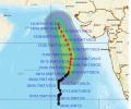
'Very severe cyclonic storm Biparjoy at 2330 hrs IST of 9th June over east-central Arabian Sea near lat 16.0N & long 67.4E. Likely to intensify further & move north-northeastwards during the next 24hrs,' the IMD said in a tweet.
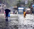
Some low-lying places like Hindmata, and areas in Dadar and Sion, including the Gandhi Market and road number 24 in Sion, were inundated, forcing pedestrians to wade through the water and making it difficult for motorists to commute.

Chief Minister Vijay Rupani said people living in the coastal belt would be shifted to safer places.

The World Meteorological Organisation/Economic and Social Commission for Asia and the Pacific Panel on Tropical Cyclones, at its twenty-seventh session held in 2000 in Muscat, Oman, agreed to assign names to the tropical cyclones in the Bay of Bengal and Arabian Sea.

There has not been a large impact of untimely rain and hailstorm so far in several major wheat-growing areas, and those might have damaged around 3 per cent of the standing crop -- not enough to make a big dent in the expected 112 million tonnes of production in FY24, a senior government official said on Tuesday. Relentless rain pounded most North Indian states all through March. Separately, the chairman of Food Corporation of India (FCI), Ashok K Meena, told reporters the agency was on track to achieve the targeted 34 million tonnes of procurement in FY24 on the back of a strong start to the purchase season from Madhya Pradesh.

Around 300 people, mostly tourists, are stuck in camps at Chandertal, located at an altitude of 14,100 feet, following rain and snowfall in the region.

Heavy rains triggered by a deep depression in the weather system claimed as many 38 lives in Gujarat on Wednesday.

The cyclonic storm is likely to move nearly westwards and cross north Andhra Pradesh-south Odisha coasts between Kalingapatnam and Gopalpur around Sunday evening, the Cyclone Warning Division of the IMD said.
R D Singh, director of MET, said conditions are favourable for further advance of the monsoon into remaining parts of coastal and south interior Karnataka during the next 48 hours.

In Uttar Pradesh, the death toll due to lightning strikes rose to 42.

The state government asked the local administration to shift people from low-lying areas in Vadodara if needed as water entered into houses in several localities.

NDRF, with the help of local authorities and police, has been conducting evacuation operations to minimise the potential damage from the cyclone.

Apart from the human body, human food will bear direct repercussions. From staples such as wheat, to coffee, dairy, and even the great Hilsa face the threat of reduced supply due to the extreme heat.

The state government has begun preparations to deal with the fallout of the cyclone as it will bring very strong wind and heavy rainfall in the region, officials said.

The southwest monsoon has started on a weak note and this has delayed the sowing of kharif crops. Though a cause for concern, the situation hasn't reached a stage where it warrants any panic response. Moreover, according to meteorologists and industry players, monsoon rains will witness a revival in the coming few weeks.

The weatherman said when 'Amphan' makes the landfall between West Bengal's Digha, some 180 km from Kolkata, and Hatiya island in Bangladesh on Wednesday afternoon or evening, it will pack sustained wind speed of 155 to 165 kmph, gusting at 185 kmph. The gale-force wind, blowing at a speed of 240 to 250 kmph and gusting to 275 kmph at one point, had lost intensity and was moving at a speed of 200 to 210 kmph, gusting to 230 kmph on Tuesday evening.

The entire coastal region of Odisha has been experiencing rainfall since Friday night.

Kerala has been receiving rainfall since Saturday and 10 out of the 14 weather monitoring stations in the state have received more than 2.5 mm rains.

Above-normal heatwave days are predicted in most parts of central, east and northwest India during this period.

The cyclone expected to weaken gradually over the next two days.
It has so far received 6.8 cm snowfall.

The powerful cyclone, strongest to hit India in 20 years, made landfall at around 8 am in India's eastern state of Odisha, killing at least 12 people.

The IMD had said the Southwest Monsoon would hit parts of north India including Delhi on July 10, but it had not occurred till Sunday evening.

'There was a slight change of direction towards north-eastwards which meant the impact of the cyclone on Mumbai was less severe than originally expected,' the IMD said in a statement.

The Met Department has predicted light to moderate rainfall across parts of West Bengal, Andhra Pradesh and Odisha with the probability of the severe cyclonic storm 'Asani' recurving.

IMD director general Mrutunjay Mohapatra said that cyclone Asani has already achieved maximum stage of intensification and is gradually getting weakened.

Gale-force winds, heavy rainfall and high tidal waves swept the coastal belt of Kerala, Karnataka and Goa as Cyclone Tauktae hurtled northwards towards Gujarat on Sunday, leaving four people dead in Karnataka and two in Goa, damaging hundreds of houses, uprooting electricity poles and trees and forcing evacuation.

The cyclone is likely to bring heavy rainfall in its wake in parts of Maharashtra, Gujarat and Goa. The light showers/drizzle in parts of Mumbai city, its suburbs and neighbouring districts of Thane and Palghar on Monday morning brought some respite to people from the sweltering heat and humidity.

Scores of people die every year due to cold waves that sweep across the north Indian plains.

The rainfall in July was minus seven per cent which comes to around 93 per cent of the Long Period Average, IMD Director General Mrutyunjay Mohapatra said.

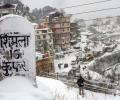
The Srinagar-Jammu national highway, the only all-weather road linking Kashmir to the rest of the country, was closed for vehicular traffic as the valley including Srinagar experienced fresh snowfall on Wednesday.

The orange alert has been issued for moderate or heavy thunderstorms and wind speed with 30-40 km per hour to reach some districts of Odisha within the next three hours.

By now, monsoon should have reached the central India, including parts of Madhya Pradesh, Rajasthan, eastern Uttar Pradesh and Gujarat, but it is yet to reach Maharashtra.

With the cyclone set to make landfall on Wednesday, Maharashtra and Gujarat activated their disaster response mechanism, deploying NDRF teams and evacuating people from areas likely to be hit.

Several global models are predicting El Nio to appear around the second half of the year, which are the crucial rain-bearing months.

Moderate to rather heavy rains are likely at many places over all districts of coastal Tamil Nadu and Puducherry on Monday as a low pressure area would form over the Southwest Bay.

The trough over the Bay of Bengal, which has caused the torrential downpour in the state, will weaken in next 48 hours.

The CM has asked all the 51 district collectors to be alert and agile to deal with the flood situation and extend immediate help to the people in distress.

IMD Director General Dr Mrutyunjay Mohapatra said that 'Yaas' is likely to intensify into a Very Severe Cyclonic Storm by Tuesday evening and Chandbali is likely to witness the maximum damage caused by it.